
Mapping Turtle Locations
Using a GPS Unit: Get coordinates exactly where the turtle was found. If you do not have access to a GPS unit, you can look up the location when you enter the data online but be sure to have a very detailed description of the turtle’s location.
Settings on your GPS unit:
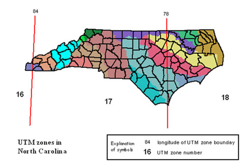
Datum: WGS 84
Record in UTMs – note which UTM Zone you are in (will be Zone 16, 17, or 18; most BTC sites are in zone 17)
Record the following for each turtle’s location:
– UTM Easting and UTM Northing
– UTM Zone — your GPS unit will give this to you
Location Description: Is not a habitat description
Where is the turtle on your property?
– Include approximate distances
– Include direction
– Use relatively permanent landmarks
Good: Visitor Center building, Lake, trails, huge boulders/rock outcroppings
Bad: trees, other plants, animal burrows, picnic tables, other temporary landmarks
– Acts as a backup to the GPS point
Examples of Location Description:
– Approx 50 m Northwest of intersection of Pine Knoll trail and Betty Jane trail
– ¼ mile directly South from lake outflow area
– On nature trail about 200 m East from the cabin